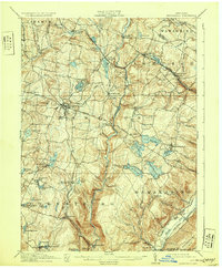
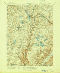
1911 Map of Monticello
USGS Topo · Published 1931About this map
Monticello serves as the central hub for Sullivan County in the early twentieth century, situated at the junction of the Newburgh and Cochecton Road and various local thoroughfares. This period of development is heavily influenced by the New York Ontario and Western RR, which connects settlements like Hurleyville, Luzon Sta, and South Fallsburgh to broader regional markets. The landscape is characterized by a high density of water bodies, ranging from natural features like Kiamesha Lake and Sackett Lake to industrial and recreationally significant sites such as Wolf Reservoir and Yankee Reservoir. The southern reaches are marked by the steep descent of the Neversink River through Denton Falls and High Falls, while planned community spaces like Mamakating Park and Merriewold Park suggest the area's emerging role as a destination for summer retreats and outdoor leisure.
Find a feature on this map
82 named features on this map. Tap any name to fly to it.
Don’t see what you’re looking for? This feature index may not catch every label — zoom into the map to look around manually.
Map Details
Editions of this 1911 Monticello Map
6 editions found

Other maps of this area

1903 · Slide Mountain
USGS Topo · 1:62,500

1904 · Ellenville
USGS Topo · 1:62,500

1905 · Slide Mountain
USGS Topo · 1:62,500

1906 · Ellenville
USGS Topo · 1:62,500

1906 · Port Jervis
USGS Topo · 1:62,500

1906 · Goshen
USGS Topo · 1:62,500

1908 · Goshen
USGS Topo · 1:62,500

1908 · Port Jervis
USGS Topo · 1:62,500

1909 · Monticello
USGS Topo · 1:62,500

1910 · Neversink
USGS Topo · 1:62,500