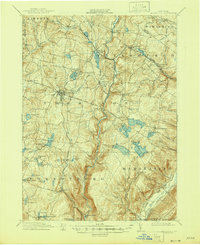
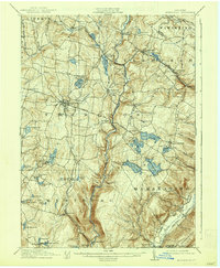
1911 Map of Monticello
USGS Topo · Published 1946About this map
Monticello serves as the central hub of this early 20th-century landscape, a period when Sullivan County was maturing into a premier summer retreat destination. The transportation network is dominated by the New York Ontario and Western RR, which connects key stops like Luzon Sta and Merriewold St Josephs Sta, facilitating the growth of planned communities and resorts. The map reveals a dense concentration of water bodies utilized for both recreation and industry, including Pleasure Lake, Kiamesha Lake, and the expansive Lords Reservoir. To the south and east, the terrain rises toward the Shawangunk Mts, while the Neversink River carves a significant valley through the center of the sheet. Established settlements like South Fallsburgh, Glenwild, and Oakland Valley are shown alongside early turnpikes such as the Newburgh and Cochecton Road.
Find a feature on this map
77 named features on this map. Tap any name to fly to it.
Don’t see what you’re looking for? This feature index may not catch every label — zoom into the map to look around manually.
Map Details
Editions of this 1911 Monticello Map
6 editions found

Other maps of this area

1903 · Slide Mountain
USGS Topo · 1:62,500

1904 · Ellenville
USGS Topo · 1:62,500

1905 · Slide Mountain
USGS Topo · 1:62,500

1906 · Ellenville
USGS Topo · 1:62,500

1906 · Port Jervis
USGS Topo · 1:62,500

1906 · Goshen
USGS Topo · 1:62,500

1908 · Goshen
USGS Topo · 1:62,500

1908 · Port Jervis
USGS Topo · 1:62,500

1909 · Monticello
USGS Topo · 1:62,500

1910 · Neversink
USGS Topo · 1:62,500