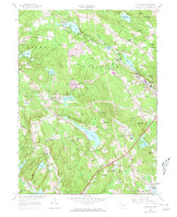
1958 Map of Montville
USGS Topo · Published 1971About this map
Oxoboxo Lake and the surrounding watersheds of New London County anchor this mid-century look at eastern Connecticut's evolving landscape. The map details the transition from rural agricultural roots to more established suburban and industrial patterns, specifically around Montville and Oakdale. A high density of family-named burial grounds like Raymond Hill Cem and Forsythe Cem suggests long-standing deep ancestral ties to the land, while the presence of the Fair Oaks Sch and Waterford Country Sch indicates the growth of local infrastructure. The terrain is defined by a series of prominent hills, including Cochegan Hill and Noble Hill, which separate numerous water bodies such as Lake Konomoc and Stony Brook Reservoir. This particular edition includes 1970 highway revisions, highlighting the modernization of the Salem Turnpike and other regional corridors that began to reshape the connectivity between towns like Chesterfield and Salem.
Find a feature on this map
97 named features on this map. Tap any name to fly to it.
Don’t see what you’re looking for? This feature index may not catch every label — zoom into the map to look around manually.
Map Details
Editions of this 1958 Montville Map
4 editions found
Other maps of this area

1892 · New London
USGS Topo · 1:62,500

1892 · Norwich
USGS Topo · 1:62,500

1892 · Gilead
USGS Topo · 1:62,500

1893 · New London
USGS Topo · 1:62,500

1893 · Saybrook
USGS Topo · 1:62,500

1921 · New London
USGS Topo · 1:62,500

1934 · Niantic
USGS Topo · 1:24,000

1935 · Montville
USGS Topo · 1:24,000

1938 · New London
USGS Topo · 1:31,680

1938 · Niantic
USGS Topo · 1:62,500