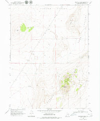
1968 Map of Monument Peak
USGS Topo · Published 1979About this map
Hansel Mountains rise sharply in this 1960s survey of Box Elder County, anchored by the prominent Monument Peak. The terrain is defined by the broad, arid stretches of Curlew Valley to the north and Sage Valley to the east, illustrating a landscape managed for grazing and sparse industrial utility. Evidence of remote human activity is limited to functional markers such as a Storage Bin, a Water Tank, and a Borrow Pit, alongside several benchmarked locations and a lone Well. This topographic record provides a clear view of the high-desert geography before later developments, highlighting named landforms like Cedar Hill and Johnson Hill that serve as primary navigational landmarks in an otherwise open and unpopulated territory.
Find a feature on this map
21 named features on this map. Tap any name to fly to it.
Don’t see what you’re looking for? This feature index may not catch every label — zoom into the map to look around manually.
Map Details
Editions of this 1968 Monument Peak Map
2 editions found
Other maps of this area

1954 · Brigham City
USGS Topo · 1:250,000

1958 · Brigham City
USGS Topo · 1:250,000

1962 · Brigham City
USGS Topo · 1:250,000

1968 · Lake Ridge
USGS Topo · 1:24,000

1968 · Monument Point
USGS Topo · 1:24,000

1968 · Salt Wells
USGS Topo · 1:24,000

1968 · Monument Peak NW
USGS Topo · 1:24,000

1968 · Monument Peak SW
USGS Topo · 1:24,000

1968 · Snowville
USGS Topo · 1:24,000

1968 · Monument Peak
USGS Topo · 1:24,000