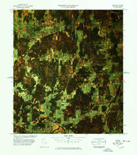
1977 Map of Mooers Station
USGS Topo · Published 1978About this map
The international border between the United States and Canada defines this 1970s orthophoto quadrangle, centered on the crossing points in northern Clinton County and southern Quebec. Unlike standard topographic sheets, this infrared imagery reveals the texture of the agricultural landscape, from the dense woodlots near Roxham to the organized fields surrounding Hemmingford. Local commerce and transit are marked by the presence of Mooers Station U. S. Customs and the Hemmingford Canadian Customs station, serving as vital gateways for the region.
Find a feature on this map
28 named features on this map. Tap any name to fly to it.
Don’t see what you’re looking for? This feature index may not catch every label — zoom into the map to look around manually.
Map Details
Editions of this 1977 Mooers Station Map
This is the sole edition of this map. No revisions or reprints were ever made.
Other maps of this area

1895 · Mooers
USGS Topo · 1:62,500

1895 · Rouse Point
USGS Topo · 1:62,500

1899 · Mooers
USGS Topo · 1:62,500

1907 · Rouse Point
USGS Topo · 1:62,500

1939 · Rouses Point
USGS Topo · 1:62,500

1942 · Mooers
USGS Topo · 1:62,500

1943 · Mooers
USGS Topo · 1:62,500

1943 · Rouses Point
USGS Topo · 1:62,500

1950 · Lake Champlain
USGS Topo · 1:250,000

1956 · Rouses Point
USGS Topo · 1:62,500