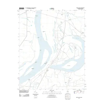
2011 Map of Moon Lake
USGS Topo · Published 2011About this map
Mississippi River dynamics define this landscape on the border of Arkansas and Mississippi, where the river's shifting course has left behind significant oxbow features and river-bottom landings. The massive crescent of Moon Lake dominates the eastern half of the quadrangle, separated from the main channel by Alcorn Island and the Montezuma Towhead. This 2011 survey documents a network of rural settlements and agricultural infrastructure, including Delta, Powell, and Danforth. For genealogists and local historians, the map is a vital resource for locating several rural burial grounds such as Mount Nebo Cemetery, Thompson Cemetery, and Fredonia Cemetery. The riverbank itself remains punctuated by historical points of transit like Fitzhugh Landing and Williamson Landing, while the interior is crisscrossed by drainage and flood control features like Whittaker Bayou and the Delta-Friars Point Revetment.
Find a feature on this map
53 named features on this map. Tap any name to fly to it.
Don’t see what you’re looking for? This feature index may not catch every label — zoom into the map to look around manually.
Map Details
Editions of this 2011 Moon Lake Map
This is the sole edition of this map. No revisions or reprints were ever made.
Other maps of this area

1908 · Lula
USGS Topo · 1:24,000

1908 · Dundee
USGS Topo · 1:24,000

1908 · Coahoma
USGS Topo · 1:24,000

1908 · Moon Lake
USGS Topo · 1:24,000

1908 · Jonestown
USGS Topo · 1:24,000

1910 · Dundee
USGS Topo · 1:31,680

1910 · Coahoma
USGS Topo · 1:31,680

1910 · Jonestown
USGS Topo · 1:31,680

1912 · Moon Lake
USGS Topo · 1:31,680

1912 · Lula
USGS Topo · 1:31,680