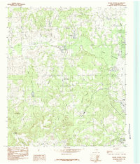
1984 Map of Moore Station
USGS Topo · Published 1984About this map
Lake Palestine dominates the eastern edge of this Henderson County landscape, where the waters of Caney Bay and Highsaw Cove reach into a terrain defined by numerous small creeks and drainage branches. The 1984 survey reveals a dispersed settlement pattern characteristic of the East Texas post-war era, with small communities like Moore Station and Antioch serving as local focal points. The map documents the persistent importance of local institutions, noting the Antioch Ch and several scattered Cem sites that provide essential data for genealogical research.
Find a feature on this map
28 named features on this map. Tap any name to fly to it.
Don’t see what you’re looking for? This feature index may not catch every label — zoom into the map to look around manually.
Map Details
Editions of this 1984 Moore Station Map
This is the sole edition of this map. No revisions or reprints were ever made.
Other maps of this area

1946 · Bullard
USGS Topo · 1:62,500

1948 · Bullard
USGS Topo · 1:62,500

1948 · Tyler
USGS Topo · 1:62,500

1948 · Brownsboro
USGS Topo · 1:62,500

1949 · Tyler
USGS Topo · 1:62,500

1949 · Brownsboro
USGS Topo · 1:62,500

1949 · Frankston
USGS Topo · 1:62,500

1950 · Frankston
USGS Topo · 1:62,500

1956 · Tyler
USGS Topo · 1:250,000

1966 · Chandler
USGS Topo · 1:24,000