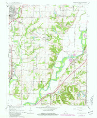
1965 Map of Mooresville East
USGS Topo · Published 1981About this map
The White River winds through the heart of this Morgan County landscape, shaping the development of riverside communities like Waverly and the high ground of The Bluffs. In the mid-1960s, this area reflects a mix of traditional agricultural crossroads and expanding residential clusters. Significant local landmarks such as the Walnut Grove Sch and North Madison Sch serve the scattered populations of Young, Miller, and Five Points. The northern edge of the map is dominated by the town of Mooresville, where the Conrail line and Old 67 Road facilitate regional transit.
Find a feature on this map
55 named features on this map. Tap any name to fly to it.
Don’t see what you’re looking for? This feature index may not catch every label — zoom into the map to look around manually.
Map Details
Editions of this 1965 Mooresville East Map
3 editions found
Other maps of this area

1942 · Franklin
USGS Topo · 1:125,000

1947 · Franklin
USGS Topo · 1:62,500

1948 · Maywood
USGS Topo · 1:24,000

1948 · Trafalgar
USGS Topo · 1:24,000

1950 · Franklin
USGS Topo · 1:62,500

1952 · Bargersville
USGS Topo · 1:24,000

1953 · Bridgeport
USGS Topo · 1:24,000

1953 · Plainfield
USGS Topo · 1:24,000

1953 · Indianapolis
USGS Topo · 1:250,000

1955 · Cope
USGS Topo · 1:24,000