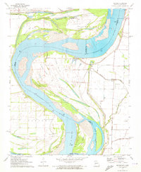
1971 Map of Mooring
USGS Topo · Published 1973About this map
The Mississippi River creates a dynamic landscape here at the tri-state junction of Missouri, Tennessee, and Kentucky during the early 1970s. This survey illustrates the intricate river morphology of the era, defined by massive sediment deposits like Island No 13, Reno Towhead, and Joe Eckles Towhead. The complex system of side channels, including the Chute of Island No 14 and Williams Chute, reveals a transition zone where the river's path is managed by a system of levees protecting the low-lying agricultural lands of Butler and Concord.
Find a feature on this map
29 named features on this map. Tap any name to fly to it.
Don’t see what you’re looking for? This feature index may not catch every label — zoom into the map to look around manually.
Map Details
Editions of this 1971 Mooring Map
2 editions found
Other maps of this area

1925 · Reelfoot Lake
USGS Topo · 1:62,500

1939 · Reelfoot Lake
USGS Topo · 1:62,500

1939 · Portageville
USGS Topo · 1:62,500

1939 · Dyersburg
USGS Topo · 1:62,500

1939 · Caruthersville
USGS Topo · 1:62,500

1951 · Caruthersville
USGS Topo · 1:62,500

1952 · Miston
USGS Topo · 1:24,000

1955 · Portageville
USGS Topo · 1:62,500

1956 · Reelfoot Lake
USGS Topo · 1:62,500

1956 · Dyersburg
USGS Topo · 1:250,000