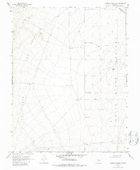
1969 Map of Moorman Spring NW
USGS Topo · Published 1987About this map
The high desert landscape of White River Valley is defined by a sparse but vital network of water sources necessary for survival and ranching in this arid part of Nye and White Pine Counties. By the late 1960s, these isolated points of utility were the primary landmarks across the basin and range terrain. Named wells such as Sorensen Well, Gubler Well, and Carter Well trace the human effort to sustain livestock and travel through the valley's wide expanses. The western portion of the map is dominated by the dramatic elevation changes of The Cove, where several minor drainages descend toward the valley floor. The placement of Government Well and Cove Well near the base of these slopes indicates a strategic reliance on groundwater at the margins of the steeper terrain, marking the intersection of topography and early Nevada land use.
Find a feature on this map
12 named features on this map. Tap any name to fly to it.
Don’t see what you’re looking for? This feature index may not catch every label — zoom into the map to look around manually.
Map Details
Editions of this 1969 Moorman Spring NW Map
2 editions found
Other maps of this area

1956 · Lund
USGS Topo · 1:250,000

1957 · Currant Mtn
USGS Topo · 1:62,500

1960 · Lund
USGS Topo · 1:250,000

1964 · Currant
USGS Topo · 1:62,500

1964 · Currant Mtn
USGS Topo · 1:62,500

1969 · Moorman Spring SE
USGS Topo · 1:24,000

1969 · Moorman Spring NW
USGS Topo · 1:24,000

1969 · Moorman Spring
USGS Topo · 1:24,000

1969 · Moorman Spring NE
USGS Topo · 1:24,000
1978 · Lund
USGS Topo · 1:24,000