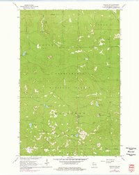
1964 Map of Moquah NW
USGS Topo · Published 1976About this map
Chequamegon National Forest dominates this landscape in northern Wisconsin, where the intersections of the Clover, Bell, Washburn, and Barksdale townships meet. The map reveals a land defined by its post-logging recovery, most notably marked by an extensive Old Railroad Grade that winds through the southern and eastern sectors. This infrastructure, alongside several pits, points to a history of resource extraction and transport that predates the 1960s photogrammetric survey.
Find a feature on this map
18 named features on this map. Tap any name to fly to it.
Don’t see what you’re looking for? This feature index may not catch every label — zoom into the map to look around manually.
Map Details
Editions of this 1964 Moquah NW Map
3 editions found
Other maps of this area

1943 · Port Wing
USGS Topo · 1:48,000

1943 · Iron Lake
USGS Topo · 1:48,000

1944 · Moquah
USGS Topo · 1:48,000

1944 · Cornucopia
USGS Topo · 1:48,000

1946 · Cornucopia
USGS Topo · 1:48,000

1946 · Port Wing
USGS Topo · 1:48,000

1947 · Moquah
USGS Topo · 1:48,000

1947 · Iron Lake
USGS Topo · 1:48,000

1953 · Ashland
USGS Topo · 1:250,000

1958 · Ashland
USGS Topo · 1:250,000