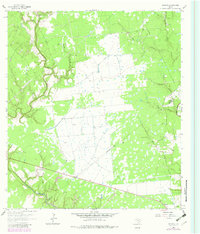
1964 Map of Morales
USGS Topo · Published 1983About this map
The Lavaca River meanders through this portion of the Texas coastal plains, defining the landscape alongside the Navidad River to the east. This 1964 survey, with 1981 edits, illustrates a rural economy transitioning through the mid-20th century, characterized by the extensive Gas Field operations that dot the territory between the river basins. The settlement of Morales anchors the southeast corner of the map, situated near the Lavaca Co Jackson Co line.
Find a feature on this map
16 named features on this map. Tap any name to fly to it.
Don’t see what you’re looking for? This feature index may not catch every label — zoom into the map to look around manually.
Map Details
Editions of this 1964 Morales Map
2 editions found
Other maps of this area

1953 · Seguin
USGS Topo · 1:250,000

1958 · Seguin
USGS Topo · 1:250,000

1962 · Hallettsville SE
USGS Topo · 1:24,000

1963 · Mount Olive
USGS Topo · 1:24,000

1964 · Cordele
USGS Topo · 1:24,000

1964 · Morales
USGS Topo · 1:24,000

1964 · Speaks
USGS Topo · 1:24,000
1964 · Navidad
USGS Topo · 1:24,000

1964 · Ezzell
USGS Topo · 1:24,000

1965 · Hope
USGS Topo · 1:24,000