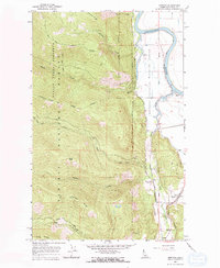
1965 Map of Moravia
USGS Topo · Published 1967About this map
Moravia and the small settlement of Burns occupy the lowland valley in Boundary County where the Kootenai River makes its dramatic northward turn. This mid-1960s landscape is defined by the sharp transition from the wetland marshes of the Kootenai National Wildlife Refuge to the steep, densely forested slopes of the Kaniksu National Forest. Transportation is a central theme, as the tracks of the Spokane International and Great Northern railroads parallel the river, serving industrial needs with the Deep Creek Siding. The map captures a moment when rural community life centered around local landmarks like the Grange Hall. Above the valley floor, the terrain rises sharply toward Snow Peak and Cascade Ridge, with a network of drainage features such as Myrtle Creek and Falls Creek carving through the mountain forest, accessible primarily by a high-altitude Pack Trail.
Find a feature on this map
32 named features on this map. Tap any name to fly to it.
Don’t see what you’re looking for? This feature index may not catch every label — zoom into the map to look around manually.
Map Details
Editions of this 1965 Moravia Map
2 editions found
Other maps of this area

1911 · Priest Lake
USGS Topo · 1:250,000

1913 · Priest Lake
USGS Topo · 1:250,000

1958 · Sandpoint
USGS Topo · 1:250,000

1963 · Sandpoint
USGS Topo · 1:250,000

1965 · Farnham Peak
USGS Topo · 1:24,000

1965 · Twentymile Creek
USGS Topo · 1:24,000

1965 · Moravia
USGS Topo · 1:24,000

1965 · Ritz
USGS Topo · 1:24,000

1965 · Naples
USGS Topo · 1:24,000
1965 · Bonners Ferry
USGS Topo · 1:24,000