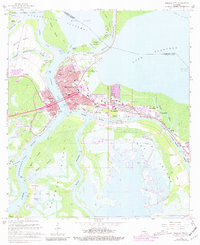
1966 Map of Morgan City
USGS Topo · Published 1981About this map
Morgan City and its neighbor Berwick occupy a critical junction where the Atchafalaya River meets the Intracoastal Waterway and the Southern Pacific railroad line. This mid-century survey reveals the industrial and maritime infrastructure of the region, from the Berwick Waterworks to the numerous Radio Towers and Pumping Stations that serve the marshy coastline. The presence of the Gas and Oil Field near Bateman Lake and scattered Oil Wells highlights the importance of energy extraction in the local economy during the 1960s.
Find a feature on this map
70 named features on this map. Tap any name to fly to it.
Don’t see what you’re looking for? This feature index may not catch every label — zoom into the map to look around manually.
Map Details
Editions of this 1966 Morgan City Map
2 editions found
Other maps of this area

1935 · Morgan City
USGS Topo · 1:62,500

1941 · Belle Isle
USGS Topo · 1:62,500

1945 · New Orleans
USGS Topo · 1:250,000

1948 · Foster
USGS Topo · 1:62,500

1953 · Napoleonville
USGS Topo · 1:62,500

1954 · Morgan City
USGS Topo · 1:62,500

1954 · Belle Isle
USGS Topo · 1:62,500

1959 · Foster
USGS Topo · 1:62,500

1963 · New Orleans
USGS Topo · 1:250,000
1965 · Grassy Lake
USGS Topo · 1:24,000