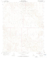
1955 Map of Morgans Well
USGS Topo · Published 1976About this map
Morgans Well stands as a vital water source in this mid-century survey of the arid San Bernardino high desert. The landscape is defined by the Bullion Mountains and the expansive Pacific Mesa, terrain that by the 1950s had become part of the Marine Corps Training Center. The map documents the intersection of military land use and earlier industrial efforts, shown through the presence of Mine Tunnels and Mine Shafts near the Naval Reservation Boundary. These features reflect a history of prospecting in a region where water sources like the northern Spring were essential for survival. Survey markers such as VABM White 4343 and VABM Black Top 2736 provide fixed points for navigating this complex topography of ridges and washes during a period of expanding federal land management.
Find a feature on this map
12 named features on this map. Tap any name to fly to it.
Don’t see what you’re looking for? This feature index may not catch every label — zoom into the map to look around manually.
Map Details
Editions of this 1955 Morgans Well Map
4 editions found
Other maps of this area

1953 · San Bernardino
USGS Topo · 1:250,000

1954 · Hidalgo Mtn
USGS Topo · 1:24,000

1954 · Ludlow SE
USGS Topo · 1:24,000

1955 · Deadman Lake NW
USGS Topo · 1:24,000

1955 · Ludlow
USGS Topo · 1:24,000

1955 · Lavic SE
USGS Topo · 1:24,000

1955 · Morgans Well
USGS Topo · 1:24,000

1955 · Deadman Lake NE
USGS Topo · 1:24,000

1955 · Ash Hill
USGS Topo · 1:24,000

1955 · Lavic Lake
USGS Topo · 1:24,000