
1961 Map of Morganton
USGS Topo · Published 1966About this map
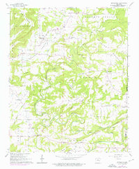
Davis Valley and the surrounding high ridges of the Ozark foothills define the landscape of this northern Arkansas region in the early 1960s. The settlement at Morganton serves as a focal point near Linn Creek, while further south, Gravesville and Batesville anchor the road network along the foothills of Barnett Mountain. The map reveals a deeply rural community structured around its watercourses and small congregations, with numerous country churches such as Mount Zion Ch, Sardis Ch, and Colony Ch dotting the hillsides.
Find a feature on this map
45 named features on this map. Tap any name to fly to it.
Don’t see what you’re looking for? This feature index may not catch every label — zoom into the map to look around manually.
Map Details
Editions of this 1961 Morganton Map
2 editions found
Other maps of this area

1892 · Mountain View
USGS Topo · 1:125,000

1894 · Mountain View
USGS Topo · 1:125,000

1956 · Russellville
USGS Topo · 1:250,000

1961 · Bee Branch
USGS Topo · 1:62,500

1961 · Bee Branch
USGS Topo · 1:24,000

1961 · Damascus
USGS Topo · 1:24,000

1961 · Guy
USGS Topo · 1:24,000

1963 · Quitman
USGS Topo · 1:24,000
1963 · Barney
USGS Topo · 1:24,000

1964 · Russellville
USGS Topo · 1:250,000