
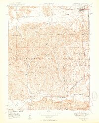
1950 Map of Morgantown
USGS Topo · Published 1950About this map
Morgantown anchors the northern portion of this 1950 survey, serving as a vital intersection point for the Illinois Central railroad. This transportation corridor dictates the settlement pattern, as the tracks follow the winding path of Bean Blossom Creek through the southern hills. Deep within the heavily wooded Yellowwood State Forest, the landscape is defined by high ridges like Carmel Ridge and Dunnaway Ridge, where small rural churches such as Ritter Chapel and Oak Ridge Ch stand as community landmarks.
Find a feature on this map
43 named features on this map. Tap any name to fly to it.
Don’t see what you’re looking for? This feature index may not catch every label — zoom into the map to look around manually.
Map Details
Editions of this 1950 Morgantown Map
2 editions found
Other maps of this area

1942 · Franklin
USGS Topo · 1:125,000

1946 · Belmont
USGS Topo · 1:24,000

1947 · Unionville
USGS Topo · 1:24,000

1947 · Nashville
USGS Topo · 1:24,000

1947 · Franklin
USGS Topo · 1:62,500

1948 · Trafalgar
USGS Topo · 1:24,000

1948 · Hindustan
USGS Topo · 1:24,000

1948 · Fruitdale
USGS Topo · 1:24,000

1948 · Morgantown
USGS Topo · 1:24,000

1949 · Nashville
USGS Topo · 1:24,000