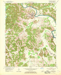
1954 Map of Morgantown
USGS Topo · Published 1969About this map
Morgantown serves as the focal point of this mid-century survey, situated within a deep bend of the Green River in central Butler County. The landscape is defined by the sinuous path of the river, which supports essential infrastructure such as Lock No 4 and the U S Reservation at Woodbury. This era reveals a rural community supported by a network of local institutions, including Pleasant Rock Ch and several country schools like Mooretown Sch and Carved Rock Sch.
Find a feature on this map
38 named features on this map. Tap any name to fly to it.
Don’t see what you’re looking for? This feature index may not catch every label — zoom into the map to look around manually.
Map Details
Editions of this 1954 Morgantown Map
2 editions found
Other maps of this area

1909 · Hartford
USGS Topo · 1:62,500

1911 · Dunmor
USGS Topo · 1:48,000

1914 · Little Muddy
USGS Topo · 1:62,500

1914 · Dunmor
USGS Topo · 1:62,500

1925 · Spring Lick
USGS Topo · 1:62,500

1953 · South Hill
USGS Topo · 1:24,000

1953 · Quality
USGS Topo · 1:24,000

1954 · Evansville
USGS Topo · 1:250,000

1954 · Welchs Creek
USGS Topo · 1:24,000
1954 · Cromwell
USGS Topo · 1:24,000