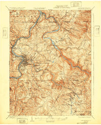
1925 Map of Morgantown
USGS Topo · Published 1932About this map
Morgantown serves as the focal point of this 1920s survey, situated where the Monongahela River meets the winding Deckers Creek. The map documents a period of industrial transition, showing the city's growth alongside established rail lines like the Baltimore and Ohio Railroad and the Monongahela Railroad. To the east, the landscape rises into the ridges of Springhill and Chestnut Ridge, where remnants of the region's early iron industry are preserved in labels like Clay Furnace, Clinton Furnace, and Laurel Iron Works.
Find a feature on this map
143 named features on this map. Tap any name to fly to it.
Don’t see what you’re looking for? This feature index may not catch every label — zoom into the map to look around manually.
Map Details
Editions of this 1925 Morgantown Map
2 editions found

Other maps of this area

1886 · St. George
USGS Topo · 1:125,000

1891 · St. George
USGS Topo · 1:125,000

1900 · Uniontown
USGS Topo · 1:62,500

1900 · Masontown
USGS Topo · 1:62,500

1901 · Waynesburg
USGS Topo · 1:62,500

1902 · Fairmont
USGS Topo · 1:62,500

1902 · Morgantown
USGS Topo · 1:62,500

1903 · Masontown
USGS Topo · 1:62,500

1904 · Bruceton
USGS Topo · 1:62,500

1904 · Blacksville
USGS Topo · 1:62,500