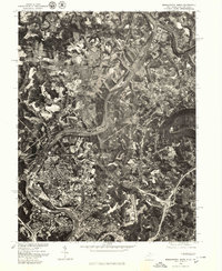
1976 Map of Morgantown North
USGS Topo · Published 1979About this map
The Monongahela River winds through this mid-1970s orthophotoquad, serving as the primary corridor for the industry and urban development of the region. This aerial perspective, captured in April 1976, reveals the dense residential and commercial expansion of Morgantown and its neighboring communities of Westover and Granville. The imagery clearly distinguishes the built-up urban center from the surrounding rural landscape, where smaller settlements like Maidsville and Taylortown sit amidst a pattern of heavy land use, including apparent surface mining and agricultural plots.
Find a feature on this map
10 named features on this map. Tap any name to fly to it.
Don’t see what you’re looking for? This feature index may not catch every label — zoom into the map to look around manually.
Map Details
Editions of this 1976 Morgantown North Map
This is the sole edition of this map. No revisions or reprints were ever made.
Other maps of this area

1900 · Masontown
USGS Topo · 1:62,500

1901 · Waynesburg
USGS Topo · 1:62,500

1902 · Morgantown
USGS Topo · 1:62,500

1903 · Masontown
USGS Topo · 1:62,500

1904 · Blacksville
USGS Topo · 1:62,500

1904 · Waynesburg
USGS Topo · 1:62,500

1923 · Blacksville
USGS Topo · 1:62,500

1925 · Blacksville
USGS Topo · 1:62,500

1925 · Morgantown
USGS Topo · 1:62,500

1931 · Masontown
USGS Topo · 1:62,500