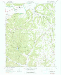
1961 Map of Morgantown
USGS Topo · Published 1990About this map
The Seip Mound State Memorial dominates the northern lowlands along Paint Creek, marking the ancient presence of the Hopewell culture in this valley long before the establishment of modern settlements like Dills and Buchanan. This 1961 survey illustrates a deeply dissected landscape where farming is concentrated in the creek bottoms, while the steep ridges of Little Copperas Mtn and Copperas Mountain remain heavily forested. The southern portion of the map is defined by the expansive Pike State Forest, which encompasses Pike Lake and high points such as Greenbrier Ridge. Local family history is preserved in a high density of rural cemeteries, including Summers Cem, Roberts Cem, and Pennisten Cem, which are often located near small country churches like Bond Chapel and the Morgan Fork Chapel. Transportation through the northern reaches follows the Detroit Toledo and Ironton Road, connecting the scattered communities of Spargursville and Nipgen.
Find a feature on this map
64 named features on this map. Tap any name to fly to it.
Don’t see what you’re looking for? This feature index may not catch every label — zoom into the map to look around manually.
Map Details
Editions of this 1961 Morgantown Map
Other maps of this area

1912 · Roxabell
USGS Topo · 1:62,500

1914 · Roxabell
USGS Topo · 1:62,500

1915 · Bainbridge
USGS Topo · 1:48,000

1915 · Piketon
USGS Topo · 1:62,500

1917 · Bainbridge
USGS Topo · 1:62,500

1917 · Piketon
USGS Topo · 1:62,500

1917 · Greenfield
USGS Topo · 1:62,500

1944 · Piketon
USGS Topo · 1:62,500

1944 · Greenfield
USGS Topo · 1:62,500

1944 · Roxabell
USGS Topo · 1:62,500