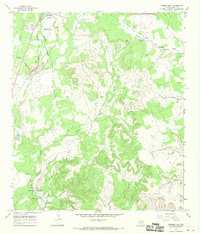
1967 Map of Mormon Mill
USGS Topo · Published 1970About this map
Burnet serves as the primary hub in this late 1960s landscape, where the southern edge of town meets a rugged Texas Hill Country terrain defined by creek drainage and scattered resource extraction. The area's heritage is anchored by the Mormon Mill (Historical Site) and its associated Mormon Mill Cem near Mill Pond, providing a rare look at mid-19th century industrial settlement patterns along Hamilton Creek. Small family burial grounds like Holland Cem, Norred Cem, and Flippin Cem are distributed across the quadrangle, marking the generational homesteads that once predominated here.
Find a feature on this map
24 named features on this map. Tap any name to fly to it.
Don’t see what you’re looking for? This feature index may not catch every label — zoom into the map to look around manually.
Map Details
Editions of this 1967 Mormon Mill Map
2 editions found
Other maps of this area

1887 · Burnet
USGS Topo · 1:125,000

1893 · Burnet
USGS Topo · 1:125,000

1903 · Burnet
USGS Topo · 1:125,000

1909 · Burnet
USGS Topo · 1:125,000

1925 · Burnet 3-d
USGS Topo · 1:48,000

1929 · Marble Falls
USGS Topo · 1:62,500

1932 · Tow
USGS Topo · 1:62,500

1932 · Marble Falls
USGS Topo · 1:62,500

1932 · Bertram
USGS Topo · 1:62,500

1954 · Llano
USGS Topo · 1:250,000