
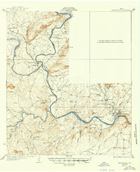
1932 Map of Marble Falls
USGS Topo · Published 1932About this map
Colorado River meanders through the central Texas hill country in the early 1930s, long before the modern Highland Lakes system transformed this stretch of the river valley. The landscape is defined by its industrial and agricultural hubs, notably at Marble Falls and Kingsland, which were linked by the Southern Pacific railroad. The importance of the local granite industry is evident at Granite Mountain and the nearby Granite Mountain Station, which served as critical points for transporting stone from the local quarries.
Find a feature on this map
56 named features on this map. Tap any name to fly to it.
Don’t see what you’re looking for? This feature index may not catch every label — zoom into the map to look around manually.
Map Details
Editions of this 1932 Marble Falls Map
2 editions found
Other maps of this area

1887 · Llano
USGS Topo · 1:125,000

1887 · Blanco
USGS Topo · 1:125,000

1887 · Burnet
USGS Topo · 1:125,000

1893 · Burnet
USGS Topo · 1:125,000

1894 · Fredericksburg
USGS Topo · 1:125,000

1894 · Blanco
USGS Topo · 1:125,000

1894 · Llano
USGS Topo · 1:125,000

1903 · Burnet
USGS Topo · 1:125,000

1904 · Llano
USGS Topo · 1:125,000

1909 · Llano
USGS Topo · 1:125,000