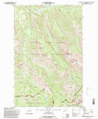
1995 Map of Morningstar Mountain
USGS Topo · Published 1997About this map
The Sawtooth Range dominates this mid-1990s topographic survey, where the Continental Divide forms a high-altitude boundary between Pondera and Flathead counties. The landscape is defined by its transition between major managed wilderness areas, including the Lewis and Clark National Forest and the Bob Marshall Wilderness. This era of mapping emphasizes recreational and conservation infrastructure, clearly marking the Continental Divide National Scenic Trail as it traverses high ridges and passes.
Find a feature on this map
34 named features on this map. Tap any name to fly to it.
Don’t see what you’re looking for? This feature index may not catch every label — zoom into the map to look around manually.
Map Details
Editions of this 1995 Morningstar Mountain Map
This is the sole edition of this map. No revisions or reprints were ever made.
Other maps of this area

1913 · Marias Pass
USGS Topo · 1:125,000

1914 · Heart Butte
USGS Topo · 1:125,000

1918 · Heart Butte
USGS Topo · 1:125,000

1958 · Gable Peaks
USGS Topo · 1:24,000

1958 · Crescent Cliff
USGS Topo · 1:24,000

1960 · Cut Bank
USGS Topo · 1:250,000

1963 · Cut Bank
USGS Topo · 1:250,000

1964 · Cut Bank
USGS Topo · 1:250,000

1968 · Half Dome Crag
USGS Topo · 1:24,000

1968 · Swift Reservoir
USGS Topo · 1:24,000