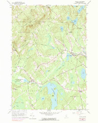
1960 Map of Morrill
USGS Topo · Published 1990About this map
Quantabacook Lake and the winding Passagassawakeag River define the hydrography of this mid-century Waldo County landscape. The settlement pattern is dominated by rural crossroads and small villages, notably Morrill, which serves as a central hub with its Smiths Millpond and local sand pits. For genealogists, the map is a vital resource for locating family burial grounds such as Hillcrest Cem near North Searsmont and Sunny Side Cem tucked within the Frye Mountain State Game Management Area.
Find a feature on this map
68 named features on this map. Tap any name to fly to it.
Don’t see what you’re looking for? This feature index may not catch every label — zoom into the map to look around manually.
Map Details
Editions of this 1960 Morrill Map
4 editions found
Other maps of this area

1915 · Belfast
USGS Topo · 1:62,500

1916 · Liberty
USGS Topo · 1:62,500

1917 · Belfast
USGS Topo · 1:62,500

1926 · Burnham
USGS Topo · 1:62,500

1932 · Brooks
USGS Topo · 1:62,500

1941 · Belfast
USGS Topo · 1:62,500

1942 · Liberty
USGS Topo · 1:62,500

1948 · Bangor
USGS Topo · 1:250,000

1950 · Belfast
USGS Topo · 1:50,000

1950 · Liberty
USGS Topo · 1:50,000