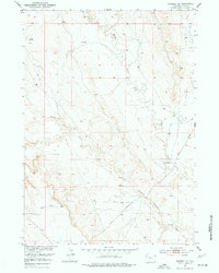
1951 Map of Morrisey NE
USGS Topo · Published 1977About this map
M Bar Ranch anchors the southeastern landscape of this Weston County terrain, situated where the Morrisey Road crosses the winding path of Beaver Creek. Mapped in the early 1950s, the area illustrates the quiet integration of ranching and energy infrastructure in eastern Wyoming. A Pipe Line cuts across the western sections of the township, connecting various Oil Well sites, including one marked as an Oil Well (Inactive). The drainage pattern is dominated by the convergence of the South Beaver Creek and its main fork, with numerous Windmill sites scattered across the plains to support local livestock. This survey provides a clear view of the mid-century petroleum development and grazing operations that define this portion of the Missouri River Basin.
Find a feature on this map
10 named features on this map. Tap any name to fly to it.
Don’t see what you’re looking for? This feature index may not catch every label — zoom into the map to look around manually.
Map Details
Editions of this 1951 Morrisey NE Map
2 editions found
Other maps of this area

1899 · Newcastle
USGS Topo · 1:125,000

1901 · Newcastle
USGS Topo · 1:125,000

1951 · Owens
USGS Topo · 1:24,000

1951 · Dewey SW
USGS Topo · 1:24,000

1951 · Newcastle
USGS Topo · 1:24,000

1951 · Morrisey NE
USGS Topo · 1:24,000

1951 · Osage SE
USGS Topo · 1:24,000

1955 · Newcastle
USGS Topo · 1:250,000

1958 · Newcastle
USGS Topo · 1:250,000
1958 · Newcastle
USGS Topo · 1:62,500