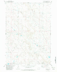
1982 Map of Morrisey SE
USGS Topo · Published 1982About this map
The high plains border between Weston Co and Niobrara Co defines the lower boundary of this western landscape. Much of the activity in this arid region centers on water management and resource extraction, evidenced by numerous Well and Tank markers scattered across the terrain. Transport is anchored by the north-south corridor of Morrisey Road, which cuts through the undulating landscape between drainage systems.
Find a feature on this map
9 named features on this map. Tap any name to fly to it.
Don’t see what you’re looking for? This feature index may not catch every label — zoom into the map to look around manually.
Map Details
Editions of this 1982 Morrisey SE Map
This is the sole edition of this map. No revisions or reprints were ever made.
Other maps of this area

1899 · Newcastle
USGS Topo · 1:125,000

1901 · Newcastle
USGS Topo · 1:125,000

1951 · Owens
USGS Topo · 1:24,000

1951 · Dewey SW
USGS Topo · 1:24,000

1951 · Morrisey NE
USGS Topo · 1:24,000

1955 · Newcastle
USGS Topo · 1:250,000

1958 · Newcastle
USGS Topo · 1:250,000

1978 · Riverview
USGS Topo · 1:24,000

1979 · Newcastle
USGS Topo · 1:100,000

1981 · Threemile Butte
USGS Topo · 1:24,000