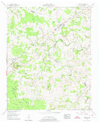
1956 Map of Morrison
USGS Topo · Published 1974About this map
The Nashville Chattanooga And ST Louis railroad cuts a diagonal line through this mid-century landscape, anchoring the commercial centers of Morrison and Summitville. Situated along the border of Warren and Coffee counties, the terrain is defined by the winding course of Hickory Creek and its significant tributary, the West Fork Hickory Creek. The map reveals a deeply settled agricultural region with a high density of family cemeteries and rural institutions, including the Ninth Model school and various small congregations such as Fountain Grove Ch and Pleasant Knoll Church.
Find a feature on this map
47 named features on this map. Tap any name to fly to it.
Don’t see what you’re looking for? This feature index may not catch every label — zoom into the map to look around manually.
Map Details
Editions of this 1956 Morrison Map
3 editions found
Other maps of this area

1893 · Mc Minnville
USGS Topo · 1:125,000

1895 · Mc Minnville
USGS Topo · 1:125,000

1895 · Sewanee
USGS Topo · 1:125,000

1913 · Hollow Springs
USGS Topo · 1:62,500

1936 · Fredonia
USGS Topo · 1:24,000

1936 · Manchester
USGS Topo · 1:24,000

1936 · Petty Gap
USGS Topo · 1:24,000

1936 · Morrison
USGS Topo · 1:24,000

1936 · Hillsboro
USGS Topo · 1:24,000

1936 · Cane Hollow
USGS Topo · 1:24,000