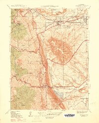
1947 Map of Morrison
USGS Topo · Published 1947About this map
The Golden and Morrison landscapes converge in this pre-war survey, defined by the geological barrier of the Hogback and the recreational development of the Front Range. The Colorado School Of Mines and the State Reformatory anchor the northern edge, while the State Military Reservation Camp George West occupies the valley floor. To the south, the intricate terrain of Red Rocks Park is fully mapped, showing the relationship between Creation Rock and the surrounding gulches. This edition captures a significant moment of transition, documenting Depression-era infrastructure like the CCC Camp alongside the early roadway systems of Lariat Loop and Alameda Parkway. Water management is prominent throughout the map, with the Agricultural Ditch and Warrior Canal snaking across the terrain to support the growing agricultural and residential needs of the region.
Find a feature on this map
51 named features on this map. Tap any name to fly to it.
Don’t see what you’re looking for? This feature index may not catch every label — zoom into the map to look around manually.
Map Details
Editions of this 1947 Morrison Map
2 editions found
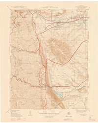
Other maps of this area

1899 · West Denver
USGS Topo · 1:125,000

1906 · Blackhawk
USGS Topo · 1:62,500

1938 · Morrison
USGS Topo · 1:24,000

1939 · Golden
USGS Topo · 1:24,000

1941 · Arvada
USGS Topo · 1:31,680

1941 · Fort Logan
USGS Topo · 1:31,680

1942 · Morrison
USGS Topo · 1:31,680

1942 · Golden
USGS Topo · 1:31,680

1942 · Littleton
USGS Topo · 1:31,680

1942 · Ralston Buttes
USGS Topo · 1:24,000