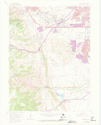
1965 Map of Morrison
USGS Topo · Published 1973About this map
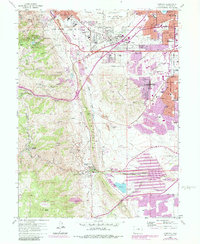
The transition from the High Plains into the Front Range foothills is captured here during a period of significant suburban expansion and institutional development. Just south of Golden, the School For Boys occupies a prominent campus near the base of South Table Mountain, while the legendary Red Rocks Amphitheater sits nestled between iconic formations like Ship Rock and Creation Rock. This area serves as a fascinating study in mixed land use, where heavy industry like the Chieftain Mine and numerous Gravel Pits operate alongside spiritual and educational sites. The Mother Cabrini Shrine and Mother Cabrini Orphanage overlook the canyon lands, illustrating the area's history as a site for religious retreats. Meanwhile, the purple-tinted growth of Green Mountain Village and Edgemont signals the post-war housing boom pushing westward from Denver toward the steep slopes of Lookout Mountain.
Find a feature on this map
117 named features on this map. Tap any name to fly to it.
Don’t see what you’re looking for? This feature index may not catch every label — zoom into the map to look around manually.
Map Details
Editions of this 1965 Morrison Map
6 editions found
Other maps of this area

1899 · West Denver
USGS Topo · 1:125,000

1906 · Blackhawk
USGS Topo · 1:62,500

1938 · Morrison
USGS Topo · 1:24,000

1939 · Golden
USGS Topo · 1:24,000

1941 · Arvada
USGS Topo · 1:31,680

1941 · Fort Logan
USGS Topo · 1:31,680

1942 · Morrison
USGS Topo · 1:31,680

1942 · Golden
USGS Topo · 1:31,680

1942 · Littleton
USGS Topo · 1:31,680

1942 · Ralston Buttes
USGS Topo · 1:24,000