
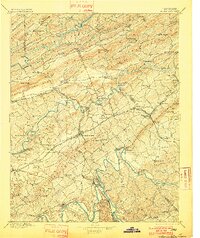
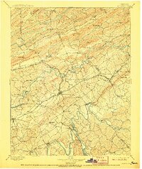
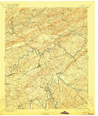
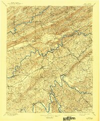
1895 Map of Morristown
USGS Topo · Published 1895About this map
Morristown serves as the central hub of this East Tennessee landscape, where the Southern R.R. (Bristol and Chattanooga Br.) and the Morristown Coal Creek and lines converge. The terrain is defined by the northeast-to-southwest grain of ridges like Clinch Mountain and Powell Mountain, which forced early transport into narrow corridors. Before the age of major bridges, the Holston River and French Broad River were crossed at numerous points such as Evans Ferry and Noe Ferry. Local industry and rural life are visible in the placement of Turley Mills and the resort character of Tate Springs. To the east, Rogersville sits near the base of the ridges, connected by the Southern R.R. (Rogersville Br.) to the main rail network at Rogersville Junction.
Find a feature on this map
114 named features on this map. Tap any name to fly to it.
Don’t see what you’re looking for? This feature index may not catch every label — zoom into the map to look around manually.
Map Details
Editions of this 1895 Morristown Map
5 editions found
Other maps of this area

1883 · Morristown
USGS Topo · 1:125,000

1886 · Knoxville
USGS Topo · 1:125,000

1886 · Cumberland Gap
USGS Topo · 1:125,000

1887 · Jonesville
USGS Topo · 1:125,000

1888 · Cumberland Gap
USGS Topo · 1:125,000

1891 · Cumberland Gap
USGS Topo · 1:125,000

1891 · Jonesville
USGS Topo · 1:125,000

1892 · Greeneville
USGS Topo · 1:125,000

1892 · Knoxville
USGS Topo · 1:125,000

1893 · Mt Guyot
USGS Topo · 1:125,000