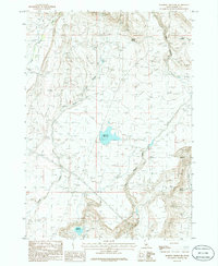
1986 Map of Morrow Reservoir
USGS Topo · Published 1986About this map
Morrow Reservoir and Blair Trail Reservoir define the water management landscape of Elmore County during the 1980s. This survey records the complex drainage system of the Idaho high desert, where seasonal and perennial flows like Alkali Creek and Little Canyon Creek cut through the terrain. The presence of numerous named water sources such as Rustican Spring, Cold Springs, and Mud Springs indicates the vital importance of spring-fed points for local livestock and land use in this arid region. High-tension transmission lines cross the landscape, signifying the infrastructure development of the mid-20th century. The intricate contours trace the steep walls of Little Canyon and the winding course of King Hill Creek, providing a detailed look at the geographic character of the area before modern satellite mapping became standard.
Find a feature on this map
10 named features on this map. Tap any name to fly to it.
Don’t see what you’re looking for? This feature index may not catch every label — zoom into the map to look around manually.
Map Details
Editions of this 1986 Morrow Reservoir Map
This is the sole edition of this map. No revisions or reprints were ever made.
Other maps of this area

1892 · Camas Prairie
USGS Topo · 1:125,000

1893 · Camas Prairie
USGS Topo · 1:125,000

1947 · Hammett
USGS Topo · 1:24,000

1947 · Glenns Ferry
USGS Topo · 1:24,000

1947 · Pasadena Valley
USGS Topo · 1:24,000

1948 · Pasadena Valley
USGS Topo · 1:24,000

1948 · Hammett
USGS Topo · 1:24,000

1948 · Glenns Ferry
USGS Topo · 1:24,000

1948 · Glenns Ferry
USGS Topo · 1:62,500

1949 · Pasadena Valley
USGS Topo · 1:62,500