
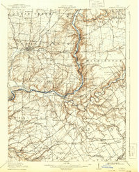
1916 Map of Morrow
USGS Topo · Published 1936About this map
Lebanon stands as the central hub of this 1914 survey, displaying a dense grid of streets and institutional landmarks including the County Infirmary and the Childrens Home. The Little Miami River snakes southward through the center of the sheet, its valley serving as a corridor for the Pennsylvania RR and the P C C and St L RR. This river-and-rail geography shaped the placement of river towns like Oregonia, Morrow, and South Lebanon.
Find a feature on this map
117 named features on this map. Tap any name to fly to it.
Don’t see what you’re looking for? This feature index may not catch every label — zoom into the map to look around manually.
Map Details
Editions of this 1916 Morrow Map
2 editions found
Other maps of this area

1898 · East Cincinnati
USGS Topo · 1:62,500

1904 · Mason
USGS Topo · 1:62,500

1906 · Mason
USGS Topo · 1:62,500

1907 · Blanchester
USGS Topo · 1:62,500

1908 · Miamisburg
USGS Topo · 1:62,500

1913 · Waynesville
USGS Topo · 1:62,500

1914 · East Cincinnati
USGS Topo · 1:62,500

1914 · Batavia
USGS Topo · 1:48,000

1914 · Morrow
USGS Topo · 1:62,500

1915 · Waynesville
USGS Topo · 1:62,500