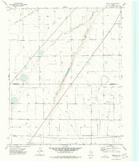
1974 Map of Morse SE
USGS Topo · Published 1977About this map
Horse Creek cuts a narrow, winding path through this high plains landscape on the border of Hansford and Hutchinson counties. In the mid-1970s, the region was defined by a dense grid of energy infrastructure, with numerous Oil Wells and Gas Wells dotting the terrain between sections. This industrial network is supported by a Pumping Sta, a local Substa, and a Radio Tower located in the southern portion of the quadrangle. The Atchison Topeka and Santa Fe railroad traverses the northwest corner, providing a critical transport link for the area's fossil fuel and agricultural output. Smaller landmarks like the Red Tank serve as navigation points in an otherwise uniform expanse of managed land and pipelines.
Find a feature on this map
9 named features on this map. Tap any name to fly to it.
Don’t see what you’re looking for? This feature index may not catch every label — zoom into the map to look around manually.
Map Details
Editions of this 1974 Morse SE Map
This is the sole edition of this map. No revisions or reprints were ever made.
Other maps of this area

1953 · Stinnett Station
USGS Topo · 1:24,000

1953 · Pringle
USGS Topo · 1:24,000

1954 · Perryton
USGS Topo · 1:250,000

1954 · Amarillo
USGS Topo · 1:250,000

1958 · Perryton
USGS Topo · 1:250,000

1958 · Amarillo
USGS Topo · 1:250,000

1962 · Hansford
USGS Topo · 1:24,000

1962 · Spearman
USGS Topo · 1:24,000

1974 · Morse
USGS Topo · 1:24,000

1974 · Hannas Draw East
USGS Topo · 1:24,000