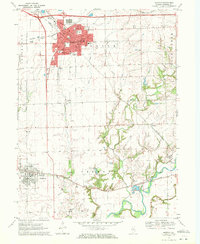
1970 Map of Morton
USGS Topo · Published 1972About this map
Morton and its surrounding central Illinois agricultural landscape are defined by a dense network of early 1970s transportation corridors and established rural institutions. The village core shows the growth of civic and social life, anchored by City Hall, the Nursing Home, and schools such as Lincoln Sch and the Blessed Sacrament Sch. Outside the growing residential center, the land transitions into a productive landscape of Gravel Pits and winding watercourses like Bull Run and Mud Creek.
Find a feature on this map
33 named features on this map. Tap any name to fly to it.
Don’t see what you’re looking for? This feature index may not catch every label — zoom into the map to look around manually.
Map Details
Editions of this 1970 Morton Map
2 editions found
Other maps of this area

1905 · Peoria
USGS Topo · 1:62,500

1927 · Peoria
USGS Topo · 1:62,500

1928 · Mackinaw
USGS Topo · 1:62,500

1932 · Mackinaw
USGS Topo · 1:62,500

1942 · Delavan
USGS Topo · 1:62,500

1949 · Peoria East
USGS Topo · 1:24,000
1950 · Peoria East
USGS Topo · 1:24,000

1951 · Minier
USGS Topo · 1:62,500

1958 · Peoria
USGS Topo · 1:250,000

1960 · Marquette Heights
USGS Topo · 1:24,000