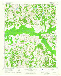
1965 Map of Moscow
USGS Topo · Published 1966About this map
Moscow stands as the primary hub in this mid-1960s landscape, situated where the Southern railroad tracks cross the broad bottomlands of the Wolf River. The surrounding Fayette County terrain is defined by a dense network of small rural institutions and family landmarks, illustrating the community structure of the era. Numerous country churches like Bethlehem Ch and Pleasant Grove Ch anchor the local road network, while smaller settlements such as Hays Crossing serve the surrounding agricultural tracts.
Find a feature on this map
40 named features on this map. Tap any name to fly to it.
Don’t see what you’re looking for? This feature index may not catch every label — zoom into the map to look around manually.
Map Details
Editions of this 1965 Moscow Map
This is the sole edition of this map. No revisions or reprints were ever made.
Other maps of this area

1943 · Collierville
USGS Topo · 1:62,500

1948 · Byhalia
USGS Topo · 1:62,500

1949 · Moscow
USGS Topo · 1:62,500

1953 · Holly Springs
USGS Topo · 1:62,500

1953 · Collierville
USGS Topo · 1:50,000

1956 · Blytheville
USGS Topo · 1:250,000

1956 · Tupelo
USGS Topo · 1:250,000

1958 · Tupelo
USGS Topo · 1:250,000

1959 · Blytheville
USGS Topo · 1:250,000

1965 · Rossville
USGS Topo · 1:24,000