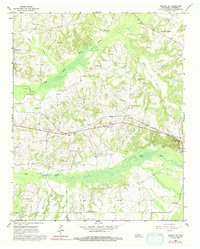
1965 Map of Moscow SE
USGS Topo · Published 1992About this map
La Grange anchors the eastern edge of this Fayette County survey, where the Southern railroad corridor cuts a path through the rolling hills of the Wolf River valley. The landscape is heavily marked by rural community centers, with family cemeteries and small country churches such as Anderson Chapel and Hickory Grove Ch serving as focal points for the surrounding farmsteads. The curiously named settlement of Forty Five sits along the rail line west of La Grange, while Rather appears as a small node further north.
Find a feature on this map
34 named features on this map. Tap any name to fly to it.
Don’t see what you’re looking for? This feature index may not catch every label — zoom into the map to look around manually.
Map Details
Editions of this 1965 Moscow SE Map
2 editions found
Other maps of this area

1949 · Moscow
USGS Topo · 1:62,500

1950 · Ashland
USGS Topo · 1:62,500

1950 · Grand Junction
USGS Topo · 1:24,000

1951 · Hickory Valley
USGS Topo · 1:24,000

1951 · Grand Junction
USGS Topo · 1:24,000

1953 · Holly Springs
USGS Topo · 1:62,500

1956 · Blytheville
USGS Topo · 1:250,000

1956 · Tupelo
USGS Topo · 1:250,000

1958 · Tupelo
USGS Topo · 1:250,000

1959 · Blytheville
USGS Topo · 1:250,000