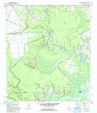
1993 Map of Moss Bluff
USGS Topo · Published 1994About this map
The Trinity River snakes through this corner of Southeast Texas, defining a landscape of complex oxbows and marshy lowlands such as Negro Bend and Demijohn Bend. In the early 1990s, this area reflects a deep-rooted hydraulic infrastructure, anchored by the Moore Bluff Pumping Sta and the Dayton Canal (Elevated), which moved water across the flat coastal plains. Industry and faith exist side-by-side near the northern boundary, where the South Liberty Oil Field sits just east of the South Dayton Ch and Heir Lawn Cem.
Find a feature on this map
43 named features on this map. Tap any name to fly to it.
Don’t see what you’re looking for? This feature index may not catch every label — zoom into the map to look around manually.
Map Details
Editions of this 1993 Moss Bluff Map
This is the sole edition of this map. No revisions or reprints were ever made.
Other maps of this area

1916 · Cedar Bayou
USGS Topo · 1:24,000

1919 · Cedar Bayou
USGS Topo · 1:31,680

1942 · Anahuac
USGS Topo · 1:24,000

1943 · Liberty
USGS Topo · 1:125,000

1943 · Cedar Bayou
USGS Topo · 1:24,000

1950 · Houston
USGS Topo · 1:250,000

1954 · Beaumont
USGS Topo · 1:250,000

1955 · Daisetta
USGS Topo · 1:62,500

1955 · Liberty
USGS Topo · 1:62,500

1956 · Houston
USGS Topo · 1:250,000