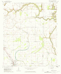
1966 Map of Mound Bayou
USGS Topo · Published 1982About this map
The town of Mound Bayou stands as a central landmark in this mid-1960s survey of the Mississippi Delta, positioned along the Illinois Central railroad. This region is defined by its intricate water systems, with the winding Hushpupckena River and Big Sunflower River carving through a landscape primarily dedicated to agriculture. The map reveals a deeply rooted community structure, evidenced by the high density of rural churches and family-named landmarks that dot the countryside.
Find a feature on this map
27 named features on this map. Tap any name to fly to it.
Don’t see what you’re looking for? This feature index may not catch every label — zoom into the map to look around manually.
Map Details
Editions of this 1966 Mound Bayou Map
2 editions found
Other maps of this area

1930 · Mellwood
USGS Topo · 1:62,500

1931 · Drew
USGS Topo · 1:48,000

1935 · Clarksdale
USGS Topo · 1:62,500

1935 · Mound Bayou
USGS Topo · 1:62,500

1939 · Pace
USGS Topo · 1:62,500

1939 · Clarksdale
USGS Topo · 1:62,500

1939 · Mellwood
USGS Topo · 1:62,500

1948 · Helena
USGS Topo · 1:250,000

1950 · Helena
USGS Topo · 1:250,000

1953 · Greenwood
USGS Topo · 1:250,000