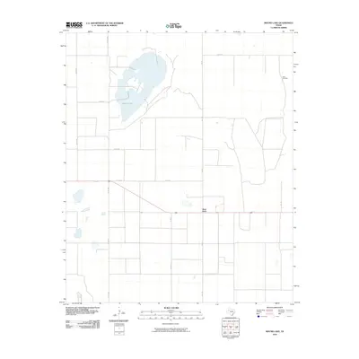
2010 Map of Mound Lake
USGS Topo · Published 2010About this map
Mound Lake dominates the upper reaches of this West Texas landscape, its irregular shoreline providing a stark contrast to the rigid grid of the surrounding agricultural region. The settlement of West Point serves as a small crossroads along Fm 179, which serves as a primary north-south artery for local commerce and transport. The geometric arrangement of roads, including Co Rd A and Co RD 440, reflects the systematic land divisions common in the High Plains. While water is scarce across the terrain, the presence of North Windmills in the northeast corner of the sheet indicates the ongoing reliance on groundwater for ranching and farming operations. The landscape is characterized by its wide-open character and intermittent water features, typical of Lynn County's rural identity in the early 21st century.
Find a feature on this map
12 named features on this map. Tap any name to fly to it.
Don’t see what you’re looking for? This feature index may not catch every label — zoom into the map to look around manually.
Map Details
Editions of this 2010 Mound Lake Map
This is the sole edition of this map. No revisions or reprints were ever made.
Other maps of this area

1954 · Lubbock
USGS Topo · 1:250,000

1954 · Brownfield
USGS Topo · 1:250,000

1957 · New Home
USGS Topo · 1:62,500

1957 · Meadow
USGS Topo · 1:62,500

1958 · Brownfield
USGS Topo · 1:250,000

1962 · Brownfield
USGS Topo · 1:250,000

1969 · Brownfield East
USGS Topo · 1:24,000

1969 · Mound Lake
USGS Topo · 1:24,000

1969 · New Moore
USGS Topo · 1:24,000
1969 · Tahoka SW
USGS Topo · 1:24,000