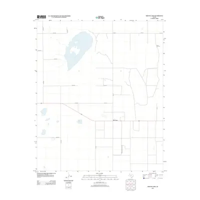
2012 Map of Mound Lake
USGS Topo · Published 2012About this map
Mound Lake dominates the upper-left quadrant of this High Plains landscape, its irregular shoreline providing a stark contrast to the rigid, mile-spaced grid of the surrounding agricultural land. In the early 21st century, this section of Lynn County remains defined by its rural layout and the small settlement of West Point. The map illustrates a highly organized transport network of local routes, including Co Road A and Farm-To-Market Road 179, which facilitate the movement of goods in this ranching and farming region. Small depressions and playa-like features are scattered across the terrain, reflecting the unique hydrology of the Llano Estacado. Evidence of local infrastructure is found in landmarks like the North Windmills, which indicate the ongoing reliance on groundwater and wind energy in this part of West Texas.
Find a feature on this map
18 named features on this map. Tap any name to fly to it.
Don’t see what you’re looking for? This feature index may not catch every label — zoom into the map to look around manually.
Map Details
Editions of this 2012 Mound Lake Map
This is the sole edition of this map. No revisions or reprints were ever made.
Other maps of this area

1954 · Lubbock
USGS Topo · 1:250,000

1954 · Brownfield
USGS Topo · 1:250,000

1957 · New Home
USGS Topo · 1:62,500

1957 · Meadow
USGS Topo · 1:62,500

1958 · Brownfield
USGS Topo · 1:250,000

1962 · Brownfield
USGS Topo · 1:250,000

1969 · Brownfield East
USGS Topo · 1:24,000

1969 · Mound Lake
USGS Topo · 1:24,000

1969 · New Moore
USGS Topo · 1:24,000
1969 · Tahoka SW
USGS Topo · 1:24,000