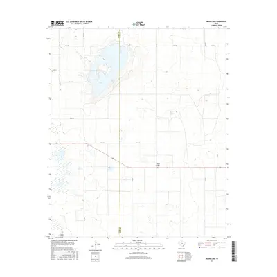
2016 Map of Mound Lake
USGS Topo · Published 2016About this map
Mound Lake dominates the upper-left quadrant of this High Plains landscape, straddling the county boundary between Terry County and Lynn County. This large alkali basin is a defining feature of the Llano Estacado, surrounded by a network of county roads that follow the rigid section lines of the regional survey grid. Further south, the small community of West Point serves as a local landmark along the east-west highway, situated near the headwaters of Lost Draw. The presence of Punch Bowl Tank reflects the essential water management practices of this semi-arid ranching and farming country. The map illustrates a sparse but functional geography where human settlement and transportation, such as Fm 179, are strictly organized around the natural depressions and draws that characterize the Texas panhandle region.
Find a feature on this map
17 named features on this map. Tap any name to fly to it.
Don’t see what you’re looking for? This feature index may not catch every label — zoom into the map to look around manually.
Map Details
Editions of this 2016 Mound Lake Map
This is the sole edition of this map. No revisions or reprints were ever made.
Other maps of this area

1954 · Lubbock
USGS Topo · 1:250,000

1954 · Brownfield
USGS Topo · 1:250,000

1957 · New Home
USGS Topo · 1:62,500

1957 · Meadow
USGS Topo · 1:62,500

1958 · Brownfield
USGS Topo · 1:250,000

1962 · Brownfield
USGS Topo · 1:250,000

1969 · Brownfield East
USGS Topo · 1:24,000

1969 · Mound Lake
USGS Topo · 1:24,000

1969 · New Moore
USGS Topo · 1:24,000
1969 · Tahoka SW
USGS Topo · 1:24,000