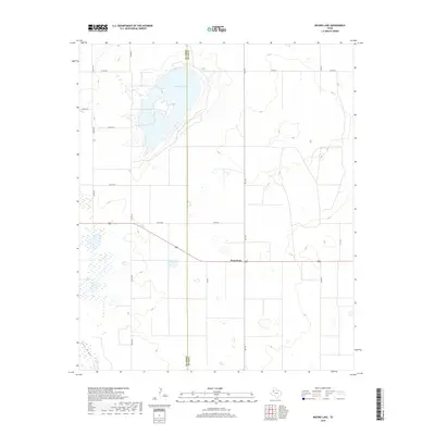
2019 Map of Mound Lake
USGS Topo · Published 2019About this map
Mound Lake dominates the upper-left quadrant of this High Plains landscape, straddling the county line between Terry Co and Lynn Co. The surrounding terrain is characterized by a grid of rural roads and scattered depressions, typical of the Llano Estacado's playa lake systems. The small community of West Point serves as a central landmark in the eastern portion of the sheet, situated along the junction of F M 179 and Co Rd 440. Further south, the topographical signature of Lost Draw cuts across the southwestern corner, indicating the ancient drainage patterns that have shaped this agricultural region. This survey captures the sparse but organized settlement pattern of West Texas, where life and transit are defined by the intersection of state-maintained farm roads and the ephemeral nature of local water basins.
Find a feature on this map
17 named features on this map. Tap any name to fly to it.
Don’t see what you’re looking for? This feature index may not catch every label — zoom into the map to look around manually.
Map Details
Editions of this 2019 Mound Lake Map
This is the sole edition of this map. No revisions or reprints were ever made.
Other maps of this area

1954 · Lubbock
USGS Topo · 1:250,000

1954 · Brownfield
USGS Topo · 1:250,000

1957 · New Home
USGS Topo · 1:62,500

1957 · Meadow
USGS Topo · 1:62,500

1958 · Brownfield
USGS Topo · 1:250,000

1962 · Brownfield
USGS Topo · 1:250,000

1969 · Brownfield East
USGS Topo · 1:24,000

1969 · Mound Lake
USGS Topo · 1:24,000

1969 · New Moore
USGS Topo · 1:24,000
1969 · Tahoka SW
USGS Topo · 1:24,000