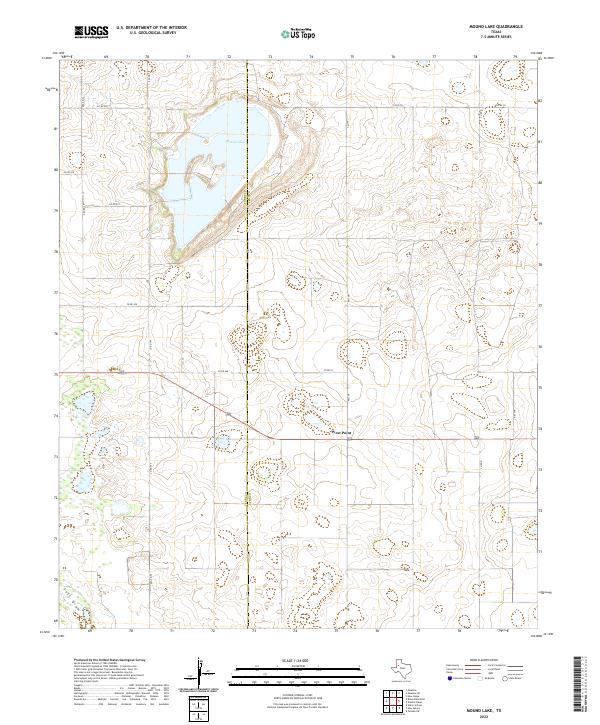
2022 Map of Mound Lake
USGS Topo · Published 2022About this map
Mound Lake spans the border of Terry and Lynn counties, serving as the dominant hydrological feature in this high plains landscape. The lake is flanked by a network of county roads, such as Co RD 400 and Co RD 585, which divide the terrain into large agricultural and ranching plots typical of the Texas Panhandle. To the south, the settlement of West Point sits along a primary east-west corridor, providing a focal point for the rural community. The presence of Lost Draw in the southwestern corner indicates the seasonal drainage patterns that define this semi-arid region. Mapping by the U.S. Geological Survey shows a landscape defined more by the survey grid and ephemeral water features than by dense urban development, offering a clear view of the area's modern rural infrastructure and land use boundaries.
Find a feature on this map
16 named features on this map. Tap any name to fly to it.
Don’t see what you’re looking for? This feature index may not catch every label — zoom into the map to look around manually.
Map Details
Editions of this 2022 Mound Lake Map
This is the sole edition of this map. No revisions or reprints were ever made.
Other maps of this area

1954 · Lubbock
USGS Topo · 1:250,000

1954 · Brownfield
USGS Topo · 1:250,000

1957 · New Home
USGS Topo · 1:62,500

1957 · Meadow
USGS Topo · 1:62,500

1958 · Brownfield
USGS Topo · 1:250,000

1962 · Brownfield
USGS Topo · 1:250,000

1969 · Brownfield East
USGS Topo · 1:24,000

1969 · Mound Lake
USGS Topo · 1:24,000

1969 · New Moore
USGS Topo · 1:24,000
1969 · Tahoka SW
USGS Topo · 1:24,000