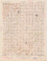
1948 Map of Mound Valley
USGS Topo · Published 1948About this map
Mound Valley and the surrounding townships of Labette County appear here during a period of established agricultural and industrial activity. The landscape is heavily defined by a dense network of rural school districts, including Cunningham Sch, Wheatland Sch, and Star Sch, which provided local education long before modern consolidation. The era's transportation and energy economy are prominently marked by the crossing of the M K T RR, St Louis - San Francisco RR, and Missouri Pacific RR, alongside numerous clusters of Oil Wells scattered across the central and southern sections of the quadrangle. Significant watercourses like Pumpkin Creek and Hackberry Creek drain the terrain toward the Kansas - Oklahoma boundary line. A notable aviation landmark from the post-war period, the U S Auxiliary Landing Field, is situated north of Edna, reflecting mid-century defense infrastructure in the Midwest.
Find a feature on this map
69 named features on this map. Tap any name to fly to it.
Don’t see what you’re looking for? This feature index may not catch every label — zoom into the map to look around manually.
Map Details
Editions of this 1948 Mound Valley Map
2 editions found
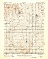
Other maps of this area

1886 · Independence
USGS Topo · 1:125,000

1886 · Parsons
USGS Topo · 1:125,000

1893 · Parsons
USGS Topo · 1:125,000

1894 · Independence
USGS Topo · 1:125,000

1901 · Nowata
USGS Topo · 1:125,000

1901 · Vinita
USGS Topo · 1:125,000

1905 · Independence
USGS Topo · 1:125,000

1913 · Vinita
USGS Topo · 1:125,000

1914 · Nowata
USGS Topo · 1:125,000

1943 · McCune
USGS Topo · 1:62,500