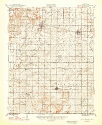
1948 Map of Mound Valley
USGS Topo · Published 1948About this map
Mound Valley and the surrounding townships of Labette County reveal a densely settled agricultural landscape in the years following World War II. The map showcases a remarkable density of rural educational and spiritual infrastructure, with schools like Prairie Hill Sch, Hiatt Sch, and Blackford Sch dotting the countryside alongside community anchors such as Elm Ch. The region's transport network is defined by several major rail lines, including the M K T and St Louis San Francisco, which facilitated the movement of goods from towns like Altamont and Edna.
Find a feature on this map
67 named features on this map. Tap any name to fly to it.
Don’t see what you’re looking for? This feature index may not catch every label — zoom into the map to look around manually.
Map Details
Editions of this 1948 Mound Valley Map
2 editions found
Other maps of this area

1886 · Independence
USGS Topo · 1:125,000

1886 · Parsons
USGS Topo · 1:125,000

1893 · Parsons
USGS Topo · 1:125,000

1894 · Independence
USGS Topo · 1:125,000

1901 · Nowata
USGS Topo · 1:125,000

1901 · Vinita
USGS Topo · 1:125,000

1905 · Independence
USGS Topo · 1:125,000

1913 · Vinita
USGS Topo · 1:125,000

1914 · Nowata
USGS Topo · 1:125,000

1943 · McCune
USGS Topo · 1:62,500