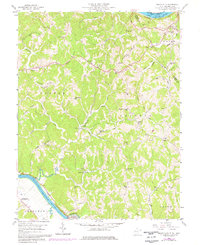
1958 Map of Mount Alto
USGS Topo · Published 1977About this map
The Ohio River and Kanawha River define the western boundaries of this landscape, where the Baltimore and Ohio and Conrail railroads follow the water's edge. Inland, the terrain is shaped by ridges like Chestnut Ridge and Plants Ridge, sheltering a network of small communities and rural institutions. Settlements such as Mount Alto, Baden, and Rollins are connected by narrow valley roads, while the presence of the Beech Hill (Southside PO) indicates the area's local postal hub.
Find a feature on this map
61 named features on this map. Tap any name to fly to it.
Don’t see what you’re looking for? This feature index may not catch every label — zoom into the map to look around manually.
Map Details
Editions of this 1958 Mount Alto Map
4 editions found
Other maps of this area

1906 · Glenwood
USGS Topo · 1:62,500

1906 · Winfield
USGS Topo · 1:62,500

1908 · Glenwood
USGS Topo · 1:62,500

1908 · Winfield
USGS Topo · 1:62,500

1908 · Ravenswood
USGS Topo · 1:62,500

1908 · Point Pleasant
USGS Topo · 1:62,500

1926 · Ravenswood
USGS Topo · 1:62,500

1926 · Point Pleasant
USGS Topo · 1:62,500

1928 · Ravenswood
USGS Topo · 1:62,500

1929 · Point Pleasant
USGS Topo · 1:62,500