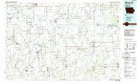
1985 Map of Mount Ayr
USGS Topo · Published 1985About this map
The rolling agricultural borderlands of southern Iowa and northern Missouri are defined by a rhythmic sequence of river forks in this mid-1980s survey. Extensive drainage systems including the Nodaway River, Platte River, and the Grand River create a corrugated landscape that dictated the placement of early rail lines and settlements. Established towns like Bedford and Mount Ayr serve as regional hubs, while smaller rail-dependent communities such as Diagonal and Clearfield appear alongside the tracks of the Burlington Northern and Chicago and North Western. This era shows a landscape shifting toward recreation and conservation, evidenced by the large Lake of Three Fires State Park and the Mount Ayr State Wildlife Management Area. Genealogists will find valuable local markers like Rose Hill Church and the adjacent Rose Hill Cemetery near Mount Ayr, providing specific points of interest for family history research.
Find a feature on this map
149 named features on this map. Tap any name to fly to it.
Don’t see what you’re looking for? This feature index may not catch every label — zoom into the map to look around manually.
Map Details
Editions of this 1985 Mount Ayr Map
2 editions found
Other maps of this area

1939 · Skidmore
USGS Topo · 1:62,500

1940 · Blockton
USGS Topo · 1:62,500

1940 · Bedford
USGS Topo · 1:62,500

1940 · Coin
USGS Topo · 1:62,500

1940 · New Market
USGS Topo · 1:62,500

1940 · Parnell
USGS Topo · 1:62,500

1941 · Skidmore
USGS Topo · 1:62,500

1942 · Skidmore
USGS Topo · 1:62,500

1942 · Grant City
USGS Topo · 1:62,500

1943 · Bedford
USGS Topo · 1:62,500