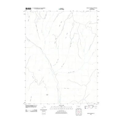
2010 Map of Mount Blaine
USGS Topo · Published 2010About this map
Mount Blaine rises as a primary landmark in this drainage-heavy landscape of Garfield County, defined by a complex network of ridges and gulches that channel water toward the southern valleys. The topography is shaped by prominent high points including Puddin Ridge, Sleepy Ridge, and Skinner Ridge, which separate the various creek systems. In the lower elevations, the Gibler Ditch represents a significant modification of the natural water flow, diverting resources through a terrain otherwise dominated by seasonal and perennial streams like Wiesse Creek and Clear Creek. Human presence is concentrated along the winding Clear Creek Rd, which follows the contours of the valley floor. This 2010 survey illustrates a region largely focused on water management and transit, where named features like Scott Spring and Deer Park Gulch provide specific reference points for land navigation and historical property boundaries.
Find a feature on this map
23 named features on this map. Tap any name to fly to it.
Don’t see what you’re looking for? This feature index may not catch every label — zoom into the map to look around manually.
Map Details
Editions of this 2010 Mount Blaine Map
This is the sole edition of this map. No revisions or reprints were ever made.
Other maps of this area

1925 · Parachute Creek
USGS Topo · 1:62,500

1927 · Parachute Creek
USGS Topo · 1:62,500

1929 · Grand Valley
USGS Topo · 1:62,500

1929 · Highmore
USGS Topo · 1:62,500

1929 · Roan Creek
USGS Topo · 1:62,500

1956 · Grand Junction
USGS Topo · 1:250,000

1959 · Grand Junction
USGS Topo · 1:250,000

1960 · Grand Junction
USGS Topo · 1:250,000

1962 · Grand Junction
USGS Topo · 1:250,000
1962 · Red Pinnacle
USGS Topo · 1:24,000