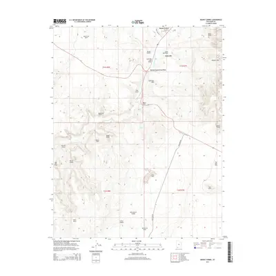
2014 Map of Mount Carmel
USGS Topo · Published 2014About this map
Mount Carmel and Orderville anchor this section of southern Utah, situated along the valley of the E Fork Virgin River. The landscape is defined by dramatic geological transitions, moving from the high elevations of the White Cliffs and Elkheart Cliffs down into complex canyon systems like Joseph Canyon and Yellowjacket Canyon. The settlement pattern follows the fertile corridor of the river and the intersection of modern transit routes, most notably at Mount Carmel Junction. Local history is preserved at the Mt Carmel Cem and near water sources such as Moncur Spring. The terrain is marked by distinctive landmarks including Dianas Throne and Monument Knoll, while the expansive The Sand Hills and Clay Flat illustrate the varied arid environment of Kane County. This survey provides a clear view of the rural homesteads and natural barriers that have shaped the development of these communities.
Find a feature on this map
39 named features on this map. Tap any name to fly to it.
Don’t see what you’re looking for? This feature index may not catch every label — zoom into the map to look around manually.
Map Details
Editions of this 2014 Mount Carmel Map
This is the sole edition of this map. No revisions or reprints were ever made.
Other maps of this area

1886 · Kanab
USGS Topo · 1:250,000

1953 · Cedar City
USGS Topo · 1:250,000

1954 · Kanab SW
USGS Topo · 1:24,000

1954 · Orderville Canyon SE
USGS Topo · 1:24,000

1954 · Kanab SE
USGS Topo · 1:24,000
1956 · Springdale SE
USGS Topo · 1:24,000

1956 · Springdale NE
USGS Topo · 1:24,000

1957 · Kanab
USGS Topo · 1:62,500

1958 · Cedar City
USGS Topo · 1:250,000

1958 · Orderville
USGS Topo · 1:62,500